Resonance Camera
Abstract
Resonance Camera is an experimental physical–computational imaging system that expands the camera beyond visible light. The current prototype focuses on environmental radiation and Earth’s magnetic field, translating normally imperceptible phenomena into visual representations.
The project initially explored direct sensing through onboard magnetometers and radiation sensors. Early tests produced readings that were inconsistent and difficult to trust at the sensitivity required for the project. Rather than forcing unreliable measurements into the imaging system, I shifted toward geographically relevant environmental datasets accessed through APIs.
A Raspberry Pi now combines image capture from an ArduinoCam with radiation, geomagnetic, and particle measurements drawn from established monitoring infrastructure. The software is designed to determine the camera’s location and retrieve the closest or most geographically relevant available dataset. The current prototype is being tested in the Boston region, but the same logic is intended to function in other locations.
1. Motivation & Contribution
Traditional cameras primarily translate visible light into images. Resonance Camera instead treats imaging as a process of measurement, computation, and translation.
The project began by attempting to capture invisible environmental information directly through low-cost magnetometers and radiation sensors. Although these components could produce readings, the data was not sufficiently stable or precise to support the kind of environmental interpretation I wanted the camera to perform.
That limitation became an important design decision.
Instead of trying to reproduce the capabilities of scientific monitoring equipment within a small prototype, the system now draws from existing environmental measurement networks whose instrumentation, calibration, and data quality are significantly more robust.
The resulting object exists between camera, sensing instrument, and computational interface.
The project explores:
imaging beyond visible light
radiation and geomagnetic data
geographically responsive environmental datasets
computational image transformation
site-specific image generation
custom hardware, CAD, and fabrication
The goal is not to suggest that radiation or magnetism have an inherent visual appearance, but to investigate how invisible environmental conditions can be translated into designed image systems.
2. System Overview
Conceptual Pipeline
Environment
↓
ArduinoCam / Visual Input
+
Camera Location
+
Nearest Available Radiation + Geomagnetic Data
↓
Raspberry Pi 4
↓
Python Processing + Data Fusion
↓
Image / Data Mapping
↓
Visual Output
Custom Python scripts collect and normalize environmental information, determine the camera’s location, identify the nearest or most geographically relevant available datasets, and use those measurements to influence the resulting image.
Earlier versions of the system incorporated onboard magnetometers and radiation sensors. These prototypes were useful for testing the concept of direct sensing, but the results were too inconsistent to serve as dependable primary inputs.
The transition to API-based environmental data was therefore not simply a software change; it emerged directly from prototyping and testing.
3. Technical Architecture
The camera uses a compact distributed hardware and software architecture.
ArduinoCam / Microcontroller
Image capture and hardware-level communication.
Raspberry Pi 4
Python-based image processing, API requests, location handling, data normalization, data fusion, and image mapping.
Networked Environmental Data
Radiation, geomagnetic, particle, and related measurements associated with the camera’s geographic region.
The Raspberry Pi acts as the central computational layer. Once location is established, the software searches for the closest or most relevant compatible measurement source and incorporates that information into the image-making process.
This allows the camera to remain physically consistent while its environmental inputs change depending on where it is used.
Full software architecture, wiring, scripts, and implementation notes are documented in the project repository:
GitHub: github.com/CJD-11/Resonance-Camera
4. Physical Prototyping
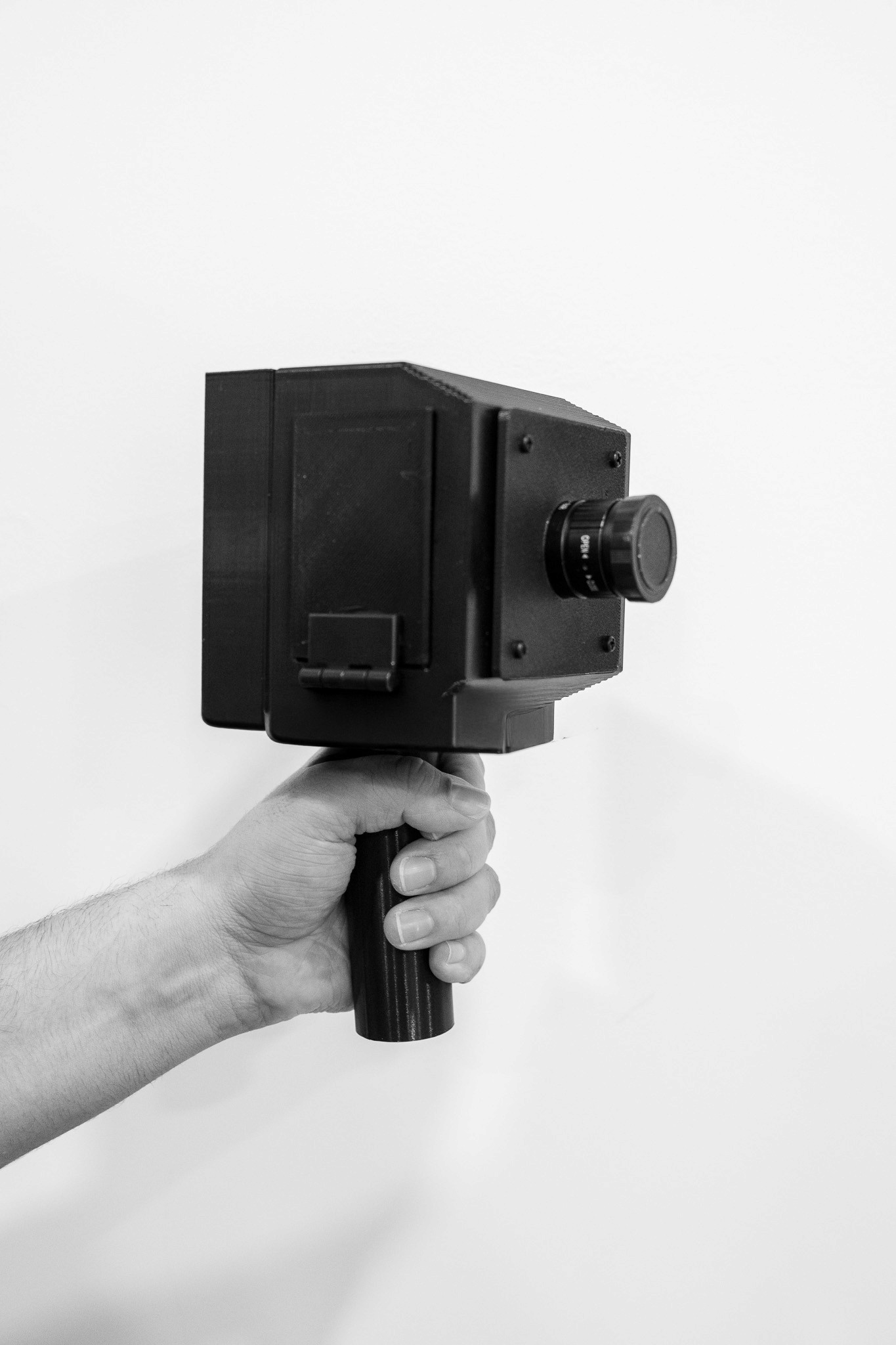
The camera body was developed as a multi-part CAD assembly approximately 160 × 110 × 89 mm.
Rather than treating the enclosure as a shell designed after the electronics were resolved, I developed the physical and electronic systems together. The body is divided into separate structural, interface, mounting, and access components so that individual sections can be modified and reprinted without redesigning the entire camera.
The development process repeatedly moved through:
CAD → print → assemble → test → revise
Physical prototypes exposed issues that were less apparent on screen, including component clearance, wiring space, mating tolerances, wall thickness, print orientation, assembly order, fastener placement, and access for repair.
The sensor experiments became part of this same iterative process. Designing around direct environmental sensing, testing those components, and ultimately deciding not to rely on their measurements changed both the internal architecture and the larger concept of the camera.
The enclosure therefore became part of the engineering process rather than simply a container for electronics:
changes in sensing, computation, fabrication, and assembly continually produced changes in form.
5. Bill of Materials
Component | Role | Approx. Cost
Raspberry Pi 4 | Primary computational platform | $55
Arduino-compatible microcontroller | Hardware control and communication | $15
ArduinoCam camera module | Image capture | $30
Magnetometer | Experimental geomagnetic sensing / prototyping | $10
Radiation / particle sensor | Experimental radiation sensing / prototyping | $60
Environmental data APIs | Regional / location-specific measurements | $0
Regulated power supply | System power | $20
Custom 3D-printed enclosure + fabricated parts | Housing, mounting, internal structure, and assembly | $100
Wiring, connectors & hardware | Internal assembly | $20
Estimated Prototype Total | | ≈ $310 USD
6. Research Context
The project draws from embodied perception, experimental imaging, scientific instrumentation, and computational media.
Maurice Merleau-Ponty’s phenomenology emphasizes perception as an embodied relationship between a person and the surrounding world.¹ Varela, Thompson, and Rosch similarly frame cognition through relationships between perception, action, body, and environment.²
These ideas inform the project’s interest in extending imaging beyond conventional optical representation.
The camera is treated not only as a device for recording appearances, but as a system for interpreting measurement.
The failed direct-sensing experiments also introduced another question:
What level of measurement quality is necessary before environmental data can responsibly become material for image-making?
Low-cost sensors made radiation and magnetic data technically accessible, but accessibility did not necessarily make that information reliable. Rather than presenting unstable readings as meaningful environmental information, I chose to connect the camera to monitoring systems capable of producing higher-quality data.
That decision reframed the camera from a self-contained sensing device into a networked, location-responsive imaging instrument.
Radiation and magnetic fields do not inherently possess a visible form. Translating them into color, density, distortion, contrast, spatial frequency, or other visual characteristics therefore requires an interpretive system.
Those mappings are design decisions.
Resonance Camera does not claim to show what these phenomena literally “look like.” Instead, it investigates how measured environmental conditions can become perceptible through computation and image-making.
7. Site-Specific Imaging
The integration of geographic location is central to the current system.
Rather than being configured permanently around a single city, the software is designed to determine where the camera is being used and search for the nearest or most relevant compatible environmental measurements.
The Boston region is the current test environment, not the limit of the architecture.
This means that geographic location becomes part of image formation rather than information added afterward.
The same camera could therefore operate in another city or region while using a different set of radiation, geomagnetic, or particle measurements.
Two visually similar environments might produce different images because they exist within different measured environmental conditions.
A place can therefore be represented not only through its visible architecture and landscape, but also through some of the invisible systems and forces associated with it.
8. Future Work
The current system already supports location-aware retrieval of nearby environmental data. Future development will focus on improving the quality and flexibility of that process rather than introducing it as a new capability.
Current directions include:
expanding compatibility with additional radiation, geomagnetic, and particle datasets
improving how multiple nearby measurement sources are compared and selected
refining the relationship between environmental measurements and image transformation
developing more sophisticated visual mapping methods
accounting for differences in measurement scale, update frequency, and data resolution
recording environmental change over time
The broader goal is to develop a camera whose representation of a place is influenced not only by what is visually present, but also by the best available measurements of the invisible environmental conditions surrounding it.
Resonance Camera is ultimately intended as a location-responsive imaging system: the physical instrument remains consistent while its environmental context changes according to where it is used.
The project asks how an imaging instrument might represent the fact that visible appearance is only one layer of information contained within a place.
Selected References
1. Merleau-Ponty, Maurice. Phenomenology of Perception. Routledge.
2. Varela, Francisco J., Evan Thompson, and Eleanor Rosch. The Embodied Mind: Cognitive Science and Human Experience. MIT Press, 1991.
Project Repository
github.com/CJD-11/Resonance-Camera
Resonance Camera
Abstract
Resonance Camera is an experimental physical–computational imaging system that expands the camera beyond visible light. The current prototype focuses on environmental radiation and Earth’s magnetic field, translating normally imperceptible phenomena into visual representations.
The project initially explored direct sensing through onboard magnetometers and radiation sensors. Early tests produced readings that were inconsistent and difficult to trust at the sensitivity required for the project. Rather than forcing unreliable measurements into the imaging system, I shifted toward geographically relevant environmental datasets accessed through APIs.
A Raspberry Pi now combines image capture from an ArduinoCam with radiation, geomagnetic, and particle measurements drawn from established monitoring infrastructure. The software is designed to determine the camera’s location and retrieve the closest or most geographically relevant available dataset. The current prototype is being tested in the Boston region, but the same logic is intended to function in other locations.
1. Motivation & Contribution
Traditional cameras primarily translate visible light into images. Resonance Camera instead treats imaging as a process of measurement, computation, and translation.
The project began by attempting to capture invisible environmental information directly through low-cost magnetometers and radiation sensors. Although these components could produce readings, the data was not sufficiently stable or precise to support the kind of environmental interpretation I wanted the camera to perform.
That limitation became an important design decision.
Instead of trying to reproduce the capabilities of scientific monitoring equipment within a small prototype, the system now draws from existing environmental measurement networks whose instrumentation, calibration, and data quality are significantly more robust.
The resulting object exists between camera, sensing instrument, and computational interface.
The project explores:
imaging beyond visible light
radiation and geomagnetic data
geographically responsive environmental datasets
computational image transformation
site-specific image generation
custom hardware, CAD, and fabrication
The goal is not to suggest that radiation or magnetism have an inherent visual appearance, but to investigate how invisible environmental conditions can be translated into designed image systems.
2. System Overview
Conceptual Pipeline
Environment
↓
ArduinoCam / Visual Input
+
Camera Location
+
Nearest Available Radiation + Geomagnetic Data
↓
Raspberry Pi 4
↓
Python Processing + Data Fusion
↓
Image / Data Mapping
↓
Visual Output
Custom Python scripts collect and normalize environmental information, determine the camera’s location, identify the nearest or most geographically relevant available datasets, and use those measurements to influence the resulting image.
Earlier versions of the system incorporated onboard magnetometers and radiation sensors. These prototypes were useful for testing the concept of direct sensing, but the results were too inconsistent to serve as dependable primary inputs.
The transition to API-based environmental data was therefore not simply a software change; it emerged directly from prototyping and testing.
3. Technical Architecture
The camera uses a compact distributed hardware and software architecture.
ArduinoCam / Microcontroller
Image capture and hardware-level communication.
Raspberry Pi 4
Python-based image processing, API requests, location handling, data normalization, data fusion, and image mapping.
Networked Environmental Data
Radiation, geomagnetic, particle, and related measurements associated with the camera’s geographic region.
The Raspberry Pi acts as the central computational layer. Once location is established, the software searches for the closest or most relevant compatible measurement source and incorporates that information into the image-making process.
This allows the camera to remain physically consistent while its environmental inputs change depending on where it is used.
Full software architecture, wiring, scripts, and implementation notes are documented in the project repository:
GitHub: github.com/CJD-11/Resonance-Camera
4. Physical Prototyping
The camera body was developed as a multi-part CAD assembly approximately 160 × 110 × 89 mm.
Rather than treating the enclosure as a shell designed after the electronics were resolved, I developed the physical and electronic systems together. The body is divided into separate structural, interface, mounting, and access components so that individual sections can be modified and reprinted without redesigning the entire camera.
The development process repeatedly moved through:
CAD → print → assemble → test → revise
Physical prototypes exposed issues that were less apparent on screen, including component clearance, wiring space, mating tolerances, wall thickness, print orientation, assembly order, fastener placement, and access for repair.
The sensor experiments became part of this same iterative process. Designing around direct environmental sensing, testing those components, and ultimately deciding not to rely on their measurements changed both the internal architecture and the larger concept of the camera.
The enclosure therefore became part of the engineering process rather than simply a container for electronics:
changes in sensing, computation, fabrication, and assembly continually produced changes in form.
5. Bill of Materials
Component | Role | Approx. Cost
Raspberry Pi 4 | Primary computational platform | $55
Arduino-compatible microcontroller | Hardware control and communication | $15
ArduinoCam camera module | Image capture | $30
Magnetometer | Experimental geomagnetic sensing / prototyping | $10
Radiation / particle sensor | Experimental radiation sensing / prototyping | $60
Environmental data APIs | Regional / location-specific measurements | $0
Regulated power supply | System power | $20
Custom 3D-printed enclosure + fabricated parts | Housing, mounting, internal structure, and assembly | $100
Wiring, connectors & hardware | Internal assembly | $20
Estimated Prototype Total | | ≈ $310 USD
6. Research Context
The project draws from embodied perception, experimental imaging, scientific instrumentation, and computational media.
Maurice Merleau-Ponty’s phenomenology emphasizes perception as an embodied relationship between a person and the surrounding world.¹ Varela, Thompson, and Rosch similarly frame cognition through relationships between perception, action, body, and environment.²
These ideas inform the project’s interest in extending imaging beyond conventional optical representation.
The camera is treated not only as a device for recording appearances, but as a system for interpreting measurement.
The failed direct-sensing experiments also introduced another question:
What level of measurement quality is necessary before environmental data can responsibly become material for image-making?
Low-cost sensors made radiation and magnetic data technically accessible, but accessibility did not necessarily make that information reliable. Rather than presenting unstable readings as meaningful environmental information, I chose to connect the camera to monitoring systems capable of producing higher-quality data.
That decision reframed the camera from a self-contained sensing device into a networked, location-responsive imaging instrument.
Radiation and magnetic fields do not inherently possess a visible form. Translating them into color, density, distortion, contrast, spatial frequency, or other visual characteristics therefore requires an interpretive system.
Those mappings are design decisions.
Resonance Camera does not claim to show what these phenomena literally “look like.” Instead, it investigates how measured environmental conditions can become perceptible through computation and image-making.
7. Site-Specific Imaging
The integration of geographic location is central to the current system.
Rather than being configured permanently around a single city, the software is designed to determine where the camera is being used and search for the nearest or most relevant compatible environmental measurements.
The Boston region is the current test environment, not the limit of the architecture.
This means that geographic location becomes part of image formation rather than information added afterward.
The same camera could therefore operate in another city or region while using a different set of radiation, geomagnetic, or particle measurements.
Two visually similar environments might produce different images because they exist within different measured environmental conditions.
A place can therefore be represented not only through its visible architecture and landscape, but also through some of the invisible systems and forces associated with it.
8. Future Work
The current system already supports location-aware retrieval of nearby environmental data. Future development will focus on improving the quality and flexibility of that process rather than introducing it as a new capability.
Current directions include:
expanding compatibility with additional radiation, geomagnetic, and particle datasets
improving how multiple nearby measurement sources are compared and selected
refining the relationship between environmental measurements and image transformation
developing more sophisticated visual mapping methods
accounting for differences in measurement scale, update frequency, and data resolution
recording environmental change over time
The broader goal is to develop a camera whose representation of a place is influenced not only by what is visually present, but also by the best available measurements of the invisible environmental conditions surrounding it.
Resonance Camera is ultimately intended as a location-responsive imaging system: the physical instrument remains consistent while its environmental context changes according to where it is used.
The project asks how an imaging instrument might represent the fact that visible appearance is only one layer of information contained within a place.
Selected References
1. Merleau-Ponty, Maurice. Phenomenology of Perception. Routledge.
2. Varela, Francisco J., Evan Thompson, and Eleanor Rosch. The Embodied Mind: Cognitive Science and Human Experience. MIT Press, 1991.
Project Repository
github.com/CJD-11/Resonance-Camera
Resonance Camera
Abstract
Resonance Camera is an experimental physical–computational imaging system that expands the camera beyond visible light. The current prototype focuses on environmental radiation and Earth’s magnetic field, translating normally imperceptible phenomena into visual representations.
The project initially explored direct sensing through onboard magnetometers and radiation sensors. Early tests produced readings that were inconsistent and difficult to trust at the sensitivity required for the project. Rather than forcing unreliable measurements into the imaging system, I shifted toward geographically relevant environmental datasets accessed through APIs.
A Raspberry Pi now combines image capture from an ArduinoCam with radiation, geomagnetic, and particle measurements drawn from established monitoring infrastructure. The software is designed to determine the camera’s location and retrieve the closest or most geographically relevant available dataset. The current prototype is being tested in the Boston region, but the same logic is intended to function in other locations.
1. Motivation & Contribution
Traditional cameras primarily translate visible light into images. Resonance Camera instead treats imaging as a process of measurement, computation, and translation.
The project began by attempting to capture invisible environmental information directly through low-cost magnetometers and radiation sensors. Although these components could produce readings, the data was not sufficiently stable or precise to support the kind of environmental interpretation I wanted the camera to perform.
That limitation became an important design decision.
Instead of trying to reproduce the capabilities of scientific monitoring equipment within a small prototype, the system now draws from existing environmental measurement networks whose instrumentation, calibration, and data quality are significantly more robust.
The resulting object exists between camera, sensing instrument, and computational interface.
The project explores:
imaging beyond visible light
radiation and geomagnetic data
geographically responsive environmental datasets
computational image transformation
site-specific image generation
custom hardware, CAD, and fabrication
The goal is not to suggest that radiation or magnetism have an inherent visual appearance, but to investigate how invisible environmental conditions can be translated into designed image systems.
2. System Overview
Conceptual Pipeline
Environment
↓
ArduinoCam / Visual Input
+
Camera Location
+
Nearest Available Radiation + Geomagnetic Data
↓
Raspberry Pi 4
↓
Python Processing + Data Fusion
↓
Image / Data Mapping
↓
Visual Output
Custom Python scripts collect and normalize environmental information, determine the camera’s location, identify the nearest or most geographically relevant available datasets, and use those measurements to influence the resulting image.
Earlier versions of the system incorporated onboard magnetometers and radiation sensors. These prototypes were useful for testing the concept of direct sensing, but the results were too inconsistent to serve as dependable primary inputs.
The transition to API-based environmental data was therefore not simply a software change; it emerged directly from prototyping and testing.
3. Technical Architecture
The camera uses a compact distributed hardware and software architecture.
ArduinoCam / Microcontroller
Image capture and hardware-level communication.
Raspberry Pi 4
Python-based image processing, API requests, location handling, data normalization, data fusion, and image mapping.
Networked Environmental Data
Radiation, geomagnetic, particle, and related measurements associated with the camera’s geographic region.
The Raspberry Pi acts as the central computational layer. Once location is established, the software searches for the closest or most relevant compatible measurement source and incorporates that information into the image-making process.
This allows the camera to remain physically consistent while its environmental inputs change depending on where it is used.
Full software architecture, wiring, scripts, and implementation notes are documented in the project repository:
GitHub: github.com/CJD-11/Resonance-Camera
4. Physical Prototyping
The camera body was developed as a multi-part CAD assembly approximately 160 × 110 × 89 mm.
Rather than treating the enclosure as a shell designed after the electronics were resolved, I developed the physical and electronic systems together. The body is divided into separate structural, interface, mounting, and access components so that individual sections can be modified and reprinted without redesigning the entire camera.
The development process repeatedly moved through:
CAD → print → assemble → test → revise
Physical prototypes exposed issues that were less apparent on screen, including component clearance, wiring space, mating tolerances, wall thickness, print orientation, assembly order, fastener placement, and access for repair.
The sensor experiments became part of this same iterative process. Designing around direct environmental sensing, testing those components, and ultimately deciding not to rely on their measurements changed both the internal architecture and the larger concept of the camera.
The enclosure therefore became part of the engineering process rather than simply a container for electronics:
changes in sensing, computation, fabrication, and assembly continually produced changes in form.
5. Bill of Materials
Component | Role | Approx. Cost
Raspberry Pi 4 | Primary computational platform | $55
Arduino-compatible microcontroller | Hardware control and communication | $15
ArduinoCam camera module | Image capture | $30
Magnetometer | Experimental geomagnetic sensing / prototyping | $10
Radiation / particle sensor | Experimental radiation sensing / prototyping | $60
Environmental data APIs | Regional / location-specific measurements | $0
Regulated power supply | System power | $20
Custom 3D-printed enclosure + fabricated parts | Housing, mounting, internal structure, and assembly | $100
Wiring, connectors & hardware | Internal assembly | $20
Estimated Prototype Total | | ≈ $310 USD
6. Research Context
The project draws from embodied perception, experimental imaging, scientific instrumentation, and computational media.
Maurice Merleau-Ponty’s phenomenology emphasizes perception as an embodied relationship between a person and the surrounding world.¹ Varela, Thompson, and Rosch similarly frame cognition through relationships between perception, action, body, and environment.²
These ideas inform the project’s interest in extending imaging beyond conventional optical representation.
The camera is treated not only as a device for recording appearances, but as a system for interpreting measurement.
The failed direct-sensing experiments also introduced another question:
What level of measurement quality is necessary before environmental data can responsibly become material for image-making?
Low-cost sensors made radiation and magnetic data technically accessible, but accessibility did not necessarily make that information reliable. Rather than presenting unstable readings as meaningful environmental information, I chose to connect the camera to monitoring systems capable of producing higher-quality data.
That decision reframed the camera from a self-contained sensing device into a networked, location-responsive imaging instrument.
Radiation and magnetic fields do not inherently possess a visible form. Translating them into color, density, distortion, contrast, spatial frequency, or other visual characteristics therefore requires an interpretive system.
Those mappings are design decisions.
Resonance Camera does not claim to show what these phenomena literally “look like.” Instead, it investigates how measured environmental conditions can become perceptible through computation and image-making.
7. Site-Specific Imaging
The integration of geographic location is central to the current system.
Rather than being configured permanently around a single city, the software is designed to determine where the camera is being used and search for the nearest or most relevant compatible environmental measurements.
The Boston region is the current test environment, not the limit of the architecture.
This means that geographic location becomes part of image formation rather than information added afterward.
The same camera could therefore operate in another city or region while using a different set of radiation, geomagnetic, or particle measurements.
Two visually similar environments might produce different images because they exist within different measured environmental conditions.
A place can therefore be represented not only through its visible architecture and landscape, but also through some of the invisible systems and forces associated with it.
8. Future Work
The current system already supports location-aware retrieval of nearby environmental data. Future development will focus on improving the quality and flexibility of that process rather than introducing it as a new capability.
Current directions include:
expanding compatibility with additional radiation, geomagnetic, and particle datasets
improving how multiple nearby measurement sources are compared and selected
refining the relationship between environmental measurements and image transformation
developing more sophisticated visual mapping methods
accounting for differences in measurement scale, update frequency, and data resolution
recording environmental change over time
The broader goal is to develop a camera whose representation of a place is influenced not only by what is visually present, but also by the best available measurements of the invisible environmental conditions surrounding it.
Resonance Camera is ultimately intended as a location-responsive imaging system: the physical instrument remains consistent while its environmental context changes according to where it is used.
The project asks how an imaging instrument might represent the fact that visible appearance is only one layer of information contained within a place.
Selected References
1. Merleau-Ponty, Maurice. Phenomenology of Perception. Routledge.
2. Varela, Francisco J., Evan Thompson, and Eleanor Rosch. The Embodied Mind: Cognitive Science and Human Experience. MIT Press, 1991.
Project Repository
github.com/CJD-11/Resonance-Camera
Menu